Via Golchijae
- Official ascent distance
- 3.2 km
- Official ascent time
- 1h 40m
For the ridge approach. At Golchijae, follow Illimsan signs rather than continuing toward Sajasan or Jeamsan.
BOSEONG · JEOLLA
Boseong · compare three Yongchu Valley ascent options, find the trailhead and follow the numbered course guide.
The county lists these distances from Yongchu Falls to the summit. They are one-way ascent figures, not parking-to-parking totals; the diagrams also show the parking approach. Allow extra time for access, descent, breaks and photographs.
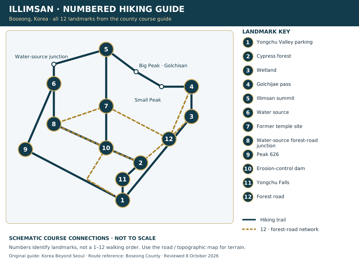
Numbers match the county’s landmark map; they are not a 1–12 walking sequence. This diagram shows stop order, not geographic scale or a GPS track. Unnumbered peaks and junctions are named separately.
For the ridge approach. At Golchijae, follow Illimsan signs rather than continuing toward Sajasan or Jeamsan.
Use the named junctions to distinguish the forest road from the summit trail. The spring is a landmark; bring your own drinking water.
The shortest of these three official ascent options. Shorter does not mean a flat or accessible walk; it still climbs to the summit.
The road map opens first. Choose Contours & trails to view terrain; zoom in to read mapped paths. Pins 4 and 5 use OpenStreetMap coordinates; other numbered landmarks have not yet been geolocated. The complete 1–12 key remains in the separate schematic below. Map paths do not confirm current access.
Schematic connections, not a scaled map or GPS route. Drag sideways on a small screen. Select a number for its landmark name. Number 12 marks the forest-road network, not one destination.
Location maps help you reach the area; they do not provide a verified hiking track. For the actual trail layout and branch directions, open the county maps below and follow on-site signs.
For a first visit, returning along the same marked trail makes junctions easier to recognise. If combining different ascent and descent routes, identify the parking return on the official map before setting out. Do not count an ascent time as the duration of the whole hike.
These routes use different starting points. Arrange the return transfer if finishing at Yongchu Valley after starting at Jeamsan recreational forest.
Check current access restrictions and mountain weather. Start early, carry water, snacks, a windproof layer, rain protection and a charged phone. Download the map beforehand; turn back if visibility or footing deteriorates.
Route figures and map landmark order checked against Boseong County information on 8 October 2026. Figures are the operator’s guidance, not a live trail-status report.
Click Biondi to chat. Drag the top bar to move this window. AI answers may need checking.
Where would you like to go?