This is a suggested route, not a live timetable or a guided tour. Book tickets and verify operating days, local transfers and trail conditions before travelling.
2days
1planning areas
4mapped stops
1flexible route
FIRST, CHOOSE YOUR TRANSPORT
How will you travel?
Select the main travel option to update the day-by-day journey notes. Confirm that your chosen service runs on your travel date before buying tickets.
Showing Train + local transport directions. Check current bookings and maps before travel.
01 / TRAVEL
How to get there
Take a train from Yongsan to Yeosu-Expo and use local transport for the harbour and Dolsan.
Check the forecast the evening before and again on departure day. For mountain days, check the official trail controls and booking rules too. These are planning alternatives, not live weather reports.
Photographs show the region or a stop on the route; the numbered list gives the order and live map links. Leave time for meals, local travel and changes in weather.
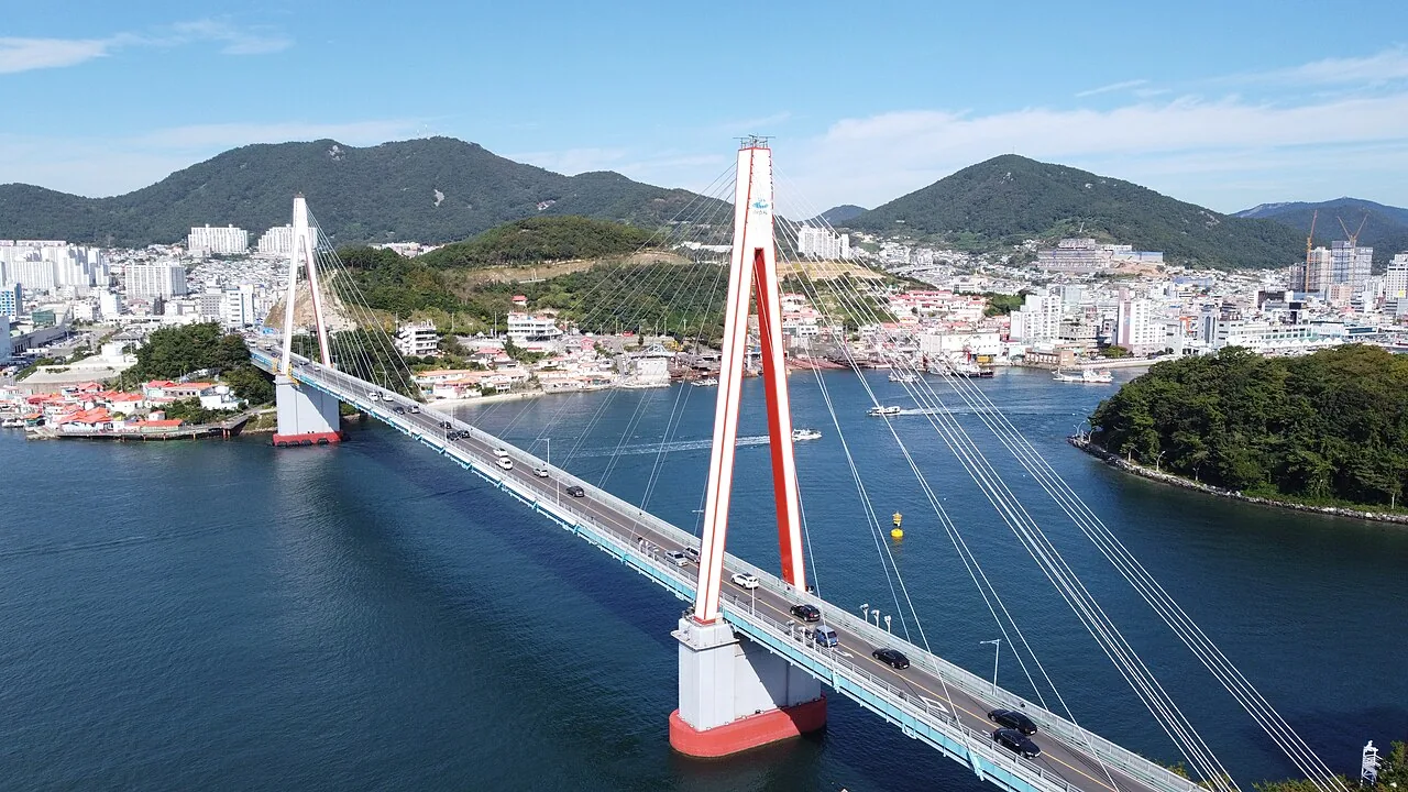
Day 1 · Geobukseon Bridge, YeosuPhoto: travel oriented · CC BY-SA 2.0 · source & licence ↗
DAY 01 · 2 days · 1 night
A harbour day
Leave luggage at your accommodation if available, then explore the island paths and harbour.
Examples of dishes, not booked restaurants. Check menus, ingredients, prices and opening hours on the day.
How to change Day 1 for the weather
Rain: Shorten exposed coast walks and use a sheltered market or museum only if open.
Heat or cold: Move outdoor stops toward a more comfortable hour and add water and a seated break.
Weather warning: Follow official warnings and operator notices. Keep the day near your base rather than forcing booked travel or an exposed walk.
Check the official forecast ↗ and current admission or trail notices for A harbour day.
Nearby to see & do
These are optional places in the wider destination. Check the distance, opening day and journey before adding a stop.
Odongdo IslandWalk across the connecting breakwater to wooded paths and coastal views. Camellia flowers are seasonal; the island is also worth visiting for the landscape. Allow for slopes and steps on the trails. Plan your visit: The island is reached from the mainland causeway, then explored on its paths. A shoreline walk and a full circuit through wooded slopes involve different distances. Allow time for the approach and return, and check local notices in strong wind or heavy rain.NAVER Map · English ↗KakaoMap · English ↗Google Maps ↗
Dolsan Bridge & the harbourFind a waterfront viewpoint for the bridge and port scenery. Plan an evening meal nearby and check the return journey to your hotel. Plan your visit: Choose a public viewpoint or waterfront path rather than stopping on a busy road for a photograph. The harbour changes between daylight and evening illumination. Plan the return transport from the specific side of the water where you finish.NAVER Map · English ↗KakaoMap · English ↗Google Maps ↗
Yeosu Maritime Cable CarThe cable car crosses the water between the mainland and Dolsan. Compare cabin types, boarding points and the last departure with the operator. Wind and weather can affect operation. Plan your visit: Check the boarding station, operating notices and ticket type before travelling. Weather or maintenance can suspend services. A return ride and a one-way journey lead to different onward plans, so decide where you want to finish before buying.NAVER Map · English ↗KakaoMap · English ↗Google Maps ↗
Goso-dong Mural VillageThe hillside lanes add art and views to an old-harbour day. Choose a comfortable route and take breaks on the climb. People live here, so keep voices low and avoid blocking doors while taking photographs.NAVER Map · English ↗KakaoMap · English ↗Google Maps ↗
Nearby day trip: Suncheon BaySuncheon is another city, not part of Yeosu's waterfront. If you have an extra day, plan travel to Suncheon and a further connection to the wetland. Keep the garden and wetland entrances distinct, and check the return journey before arranging a sunset visit.NAVER Map · English ↗KakaoMap · English ↗Google Maps ↗
Examples of dishes, not booked restaurants. Check menus, ingredients, prices and opening hours on the day.
How to change Day 2 for the weather
Rain: Shorten outdoor walks and choose an indoor museum or market only if open.
Heat or cold: Move outdoor stops toward a more comfortable hour and add water and a seated break.
Weather warning: Follow official warnings and operator notices. Keep the day near your base rather than forcing booked travel or an exposed walk.
Check the official forecast ↗ and current admission or trail notices for Views across the bay.
Nearby to see & do
These are optional places in the wider destination. Check the distance, opening day and journey before adding a stop.
Odongdo IslandWalk across the connecting breakwater to wooded paths and coastal views. Camellia flowers are seasonal; the island is also worth visiting for the landscape. Allow for slopes and steps on the trails. Plan your visit: The island is reached from the mainland causeway, then explored on its paths. A shoreline walk and a full circuit through wooded slopes involve different distances. Allow time for the approach and return, and check local notices in strong wind or heavy rain.NAVER Map · English ↗KakaoMap · English ↗Google Maps ↗
Dolsan Bridge & the harbourFind a waterfront viewpoint for the bridge and port scenery. Plan an evening meal nearby and check the return journey to your hotel. Plan your visit: Choose a public viewpoint or waterfront path rather than stopping on a busy road for a photograph. The harbour changes between daylight and evening illumination. Plan the return transport from the specific side of the water where you finish.NAVER Map · English ↗KakaoMap · English ↗Google Maps ↗
Yeosu Maritime Cable CarThe cable car crosses the water between the mainland and Dolsan. Compare cabin types, boarding points and the last departure with the operator. Wind and weather can affect operation. Plan your visit: Check the boarding station, operating notices and ticket type before travelling. Weather or maintenance can suspend services. A return ride and a one-way journey lead to different onward plans, so decide where you want to finish before buying.NAVER Map · English ↗KakaoMap · English ↗Google Maps ↗
Yi Sunsin SquareUse the square as a starting point for the old waterfront, local food and nearby lanes. It commemorates naval commander Yi Sun-sin. Plan your visit: Use the square as a starting point for the old harbour and nearby food streets. It pairs well with a relaxed meal and a short evening walk. Leave enough time for the journey back to Yeosu-Expo Station if departing the same night.NAVER Map · English ↗KakaoMap · English ↗Google Maps ↗
Goso-dong Mural VillageThe hillside lanes add art and views to an old-harbour day. Choose a comfortable route and take breaks on the climb. People live here, so keep voices low and avoid blocking doors while taking photographs.NAVER Map · English ↗KakaoMap · English ↗Google Maps ↗

 Seasoned cockles꼬막무침Seafood; ask about raw ingredientsIllustrative dish photo · Bak Ga Sangmin / Wikimedia Commons · CC BY 4.0
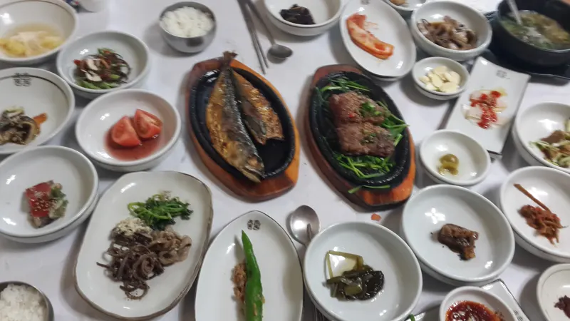 Jeolla set meal한정식A table of rice and side dishesIllustrative dish photo · Mar del Este / Wikimedia Commons · CC BY-SA 4.0
 Bibimbap비빔밥A rice bowl; compare ingredients and menusIllustrative dish photo · Douglas Paul Perkins / Wikimedia Commons · CC BY 3.0